


Fields, OR
Advertisement
Fields, OR Map
Fields is a US city in Harney County in the state of Oregon. Located at the longitude and latitude of -118.675000, 42.264100 and situated at an elevation of 4,236 meters. In the 2020 United States Census, Fields, OR had a population of 120 people. Fields is in the Pacific Standard Time timezone at Coordinated Universal Time (UTC) -8. Find directions to Fields, OR, browse local businesses, landmarks, get current traffic estimates, road conditions, and more.
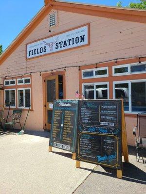
Fields, Oregon, is a remote and picturesque locale known primarily for its rugged natural beauty and its historical significance as a waystation for travelers. The town is renowned for the Fields Station, a combination of a café, motel, and gas station that serves as a beloved pit stop for adventurers exploring the vast expanses of the Alvord Desert and the Steens Mountain wilderness. The café is particularly famous for its delicious hamburgers and milkshakes, drawing visitors from far and wide who are eager to experience this culinary delight amidst the expansive, open landscapes.
Historically, Fields has served as a crucial hub for ranchers and travelers navigating the isolated high desert region of southeastern Oregon. Its origins date back to the early 20th century when it was established to support the local agricultural community. Today, Fields remains a cherished waypoint for those seeking to disconnect from the fast-paced modern world and immerse themselves in the tranquility of Oregon's high desert. Whether you're passing through on a road trip or planning a hiking excursion, Fields offers a unique glimpse into the rustic charm of rural Oregon.
Nearby cities include: Denio, NV, Plush, OR, Orovada, NV, Paradise Valley, NV, Crane, OR, Fort Bidwell, CA, New Pine Creek, OR, New Pine Creek, CA, Lakeview, OR, Lake City, CA.
Places in Fields
Dine and drink
Eat and drink your way through town.

Can't-miss activities
Culture, natural beauty, and plain old fun.
Places to stay
Hang your (vacation) hat in a place that’s just your style.


Advertisement