Illinois Scenic Drives: Great Rivers Scenic Route

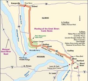
This map shows highlights along Great Rivers Scenic Route.

Within the expanse of Great Rivers Scenic Route, the Mississippi, Missouri, and Illinois Rivers meet to form a 35,000-acre floodplain. This confluence is the backdrop for the Meeting of the Great Rivers Scenic Route. The river systems have been vital transportation routes as long as there has been human habitation, moving people and goods to world markets.

The Meeting of the Great Rivers Scenic Route offers a dramatic composite of the Mississippi River. Beneath white cliffs, the byway runs next to the Mississippi, beginning in an industrial, urban setting and changing to a scenic, natural area. As though moving back through time, expanses of pastoral countryside and stone houses are reminders of a time long ago. Artifacts of the earliest aboriginal people in America reside here, and the byway's rich historical and archaeological qualities unfold. Little towns along the byway seem almost forgotten by time, giving travelers a look at historic architecture and small-town life along the Mississippi River.

Advertisement

Archaeological Qualities of Great Rivers Scenic Route

Despite present-day development, archaeological remains are largely intact along the Meeting of the Great Rivers Scenic Route. For example, the Koster Site, located south of Eldred, is world renowned because of the evidence found that shows that humans lived on the site 8,000 years ago. Structures dating back to 4200 B.C. are considered to be the oldest such habitations found in North America, and villages flourished here circa 6000 B.C., 5000 B.C., and 3300 B.C. More than 800 archaeological sites have been inventoried along the route. Experts believe that the Mississippi and Illinois Rivers, known as the Nile of North America, nourished the development of complex and sophisticated Native American cultures. So complete are cultural records that archaeologists term the area "the crossroads of prehistoric America."

Cultural Qualities of Great Rivers Scenic Route

Visitors discover real river towns along this byway. To celebrate each unique aspect of their culture, many of the communities on the byway have established their own museums. In addition, the region displays an appreciation of high culture through orchestras, theaters, galleries, institutions of higher learning, and many diverse festivals that celebrate the arts. Throughout the year, more than 50 festivals and fairs celebrate the history, art, music, and crafts of this region.

Qualities of Great Rivers Scenic Route

The Mississippi River is internationally famous. Father Jacques Marquette and Louis Jolliet first made their expedition down the Mississippi in 1673. Later, when the Illinois Territory was formed, the Missouri River was the gateway to the unexplored West, and the Illinois River led to the Great Lakes and was also a connection to the East. Early American explorers began in the confluence area. Lewis and Clark, for example, embarked from Fort Dubois near the mouth of the Missouri. Eventually, towns were settled on the shores of the rivers, providing a secure way for travel and commerce using the rivers. The buildings that composed these towns still stand, many of them dating to the early 1800s.

As the nation grew and developed, many of the towns along the byway were growing and developing as well. Although many of the towns that stand today seem to be nestled somewhere in history, some of the byway's communities have been at the edge of new ideas. During pre-Civil War times, the Underground Railroad ran through this area, bringing escaped slaves to the safety of the north. Confederate prison ruins found on the byway are another testament to this corner of Illinois' involvement in the Civil War. By the late 19th century, Mark Twain's Mississippi River stories had inspired an ideal of Mississippi legends, history, and culture in the minds of Americans. Meanwhile, as the river and its uses were also evolving, paddleboats gave way to barges and tows.

River traffic increased as industries grew, and Lock and Dam 26 was built. Today, historic 18th-century river towns, islands, bars, points, and bends create beautiful scenery beneath limestone bluffs, which are covered by forests that extend nearly 20,000 acres. Historical and cultural features in the 50-mile corridor have received national recognition, with seven sites presently registered on the National Register of Historic Places.

Qualities of Great Rivers Scenic Route

Nature abounds along the Meeting of the Great Rivers Scenic Route. The wetlands from three different waterways, the rock bluffs, and the stately trees all harbor native creatures and provide lovely views along the byway. The palisade cliffs and towering bluffs provide a characteristic drive along the riverside where visitors can see the results of this great channel of water carving its way through post-glacial terrain. You may want to enjoy the nature of the byway from the car, look for hikes along the way, or get out and explore a wildlife refuge.

Located right in the middle of the United States is Piasa country, a bird-watcher's heaven. Migratory flyways using the Mississippi, Illinois, and Missouri Rivers converge within a 25-mile zone from Alton to Grafton. This offers amazing opportunities to see many species of birds that pass through this chokepoint region, from the American bald eagle to the white pelican. Deer, otters, and beavers are present, as well as raccoons, opossums, and squirrels. Fishing enthusiasts will discover many species in the local waters.

Many natural points of interest dot this byway. For example, Pere Marquette State Park is one of Illinois' largest state parks. It is nestled along the banks of the Illinois River on the byway near Grafton. Here, a myriad of trails take you within the wild forests and up to spectacular viewing areas along the bluff line above.

The Riverlands Environmental Demonstration Area is another natural point of interest. Located near Alton, this U.S. Army Corps of Engineers site provides a fertile wetland that attracts all types of wildlife. Early-morning travelers frequently see wildlife making their way to the river. The Mark Twain Wildlife Refuge is located near Pere Marquette State Park and is often open to the public. The preserve offers sanctuary to rare and endangered migratory birds on their long flights up and down the Mississippi and Illinois Rivers.

All the stunning views that can be enjoyed from a vehicle can also be enjoyed on foot or by bike. The Sam Vadalabene Trail, a bicycle and walking trail, winds more than 25 miles from Alton to Pere Marquette State Park on the byway, making this a byway that encourages and accommodates hikers and bikers.

Qualities of Great Rivers Scenic Route

After you have seen the sights on the Meeting of the Great Rivers Scenic Route, you may decide to enjoy the surroundings on a closer level. Trails and paths along the byway offer excitement for hikers and bikers. Also, forests that line the roadsides are perfect places for camping, picnicking, or simply enjoying the peaceful solitude that nature affords. Be sure to tour the historic districts of the byway communities and stop at the museums and visitor centers that provide a closer look at the byway and its characteristics.

There is always fun to be found on the Mississippi River. Visitors enjoy the water in every way, from parasailing to jet skiing. Sailboats and riverboats keep the river alive with movement year-round. During the summer, families stop at one of the two water parks along the byway or travel on one of the four free river ferries located in the area. The Meeting of the Great Rivers Scenic Route is one of the most accommodating to bikers, with a bicycle path that goes directly along the byway.

Shopping for crafts and antiques in the historic riverside towns along the byway is a pleasant pastime, and golfers enjoy the ten courses in the region. There's a theater in Wood River and an amphitheater in Grafton for musical productions, stage productions, and other kinds of entertainment. It is hard to miss the Alton Belle Riverboat Casino on a leisurely cruise down the river. In addition to the attractions along the byway, festivals, fairs, and events are always occurring in its communities.

Find more useful information related to Illinois' Great Rivers Scenic Route:

  • Illinois Scenic Drives: Glenn Highway is just one of the scenic byways in Illinois. Check out the others.
  • How to Drive Economically: Fuel economy is a major concern when you're on a driving trip. Learn how to get better gas mileage.

Advertisement
Highlights of Great Rivers Scenic Route

Scenic river views are abundant on Great Rivers Scenic Route.

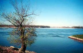
The Mississippi River is like a chameleon along Great Rivers Scenic Route. Depending on weather conditions, sun angles, and the color of the sky, the waters can turn from serene pale blue to dark navy to muddy brown. Insiders' favorite time for viewing the river is early in the morning as the sun is rising. Often, the river is glasslike, creating a mirror of the sky above. The blue is sweet and clear, and the reflections of the bluffs and trees are remarkable. Majestic bluffs tower above the byway, creating a stunning wall of trees, rocky cliffs, and soaring birds. The meandering curves of the river provide amazing views, and you can see up and down the river for miles. The bluffs, which are imposing when immediately adjacent to the road, diminish into the far horizon at several viewing areas.

Note the unusual sunsets along these parts. Most think of the Mississippi as a southbound river that cuts up and down the center of the nation. This is not true here. In Piasa country, the Mississippi River makes a distinct turn and the current flows from west to east. In Alton, Elsah, and Grafton, the sun rises and sets in the long stretch of water. On many evenings at dusk, the fiery reds, yellows, and oranges run nearly the entire length of the river. One of the great pastimes along this byway is celebrating these glorious and unique sunsets.

Advertisement

Along the road to Eldred, the bluffs give way to rolling hills, farms, and forests. Depending on the season, roadside stands with fruits and vegetables may entice you to stop. The apples and peaches in Jersey, Calhoun, and Greene Counties are legendary. In Eldred, an old-fashioned Illinois town full of Americana, most travelers stop for a slice of pie and get out to smell the crisp, fresh air. Moving northward, you see the great Illinois farmlands that bring the bounty of food to both America's and the world's dinner tables. Soon the road branches westward, and the journey ends with another free ferry over the Illinois River into Kampsville.

This byway is a must-see destination during all four seasons. In the spring, the trees and shrubs turn the bluffs and countryside into a wonderful tapestry of colorful buds and blossoms. Summer brings festivals, fairs, and river recreation. Autumn hosts the Fall Color Caravan and some of America's most amazing foliage, accented by the nearby rivers. Finally, the winter brings the American bald eagle by the hundreds to winter along the bluffs and feed along the banks of the rivers. The rivers, majestic bluffs, fantastic trees and wildlife, quaint villages, and rolling farmlands all make this byway a wonderful adventure.

This must-see tour of the Meeting of the Great Rivers Scenic Route begins at the northernmost point (Kampsville) and concludes at the southernmost point (Alton).

Kampsville: Kampsville is in Calhoun County on the Illinois River. Take the free ferry ride (drive east on Highway 108 approximately five miles to Eldred), and go to the home of the American Center for Archaeology, which is the site of Old Settlers Days with Lewis and Clark and Civil War and other reenactments.

Eldred: Eldred is a wonderful village in Greene County at Highway 108 and Blacktop Road. The Eldred Home shows a glimpse of life in the 1800-1900s. Turn south onto Blacktop Road. Drive approximately 15 miles to the intersection of Blacktop Road, Highway 100, and Highway 16; continue straight ahead and onto Highway 100 southbound. Drive approximately ten miles south to Pere Marquette State Park.

Pere Marquette State Park: This park is in Jersey County on Route 100. This 7,895-acre preserve overlooks the Mississippi and Illinois Rivers. Outdoor enthusiasts will enjoy the park's nature trails, prehistoric sites, horseback riding, camping, fishing, boating, and hiking. The park also has a wonderful lodge built in the 1930s by the Civilian Conservation Corps. The fireplace alone soars 50 feet into the grand hall, and the great room is rich with massive timber beams and stone. Continue southward out of Pere Marquette State Park onto Highway 100. Drive approximately three miles to Brussells Ferry.

Brussells Ferry: Take a free ride on the Brussells Ferry across the Illinois River, and get a feel of the river under the wheels of your vehicle. Nearby is the Mark Twain Wildlife Refuge, the seasonal home for hundreds of thousands of migratory birds including American bald eagles, herons, owls, pelicans, geese, ducks, and many rare species.

Grafton: Grafton is on Highway 100 in Jersey County. All but wiped out by the Great Flood of 1993, this amazing river town bounced back and is now considered one of the most important stops on the byway. Bed-and-breakfasts, inns, antiques and specialty shops, casual family dining, riverside entertainment, summer outdoor family amphitheater, a small museum, a visitor center, parasailing, jet skiing, pontoon boats, fishing, hunting, hiking, bike trails, cottages, horseback riding, a mystery dinner theater, and more can be found in Grafton. Festivals abound throughout the spring, summer, and fall. Continue southbound approximately a half mile to the bluffs running along the Mississippi River.

Scenic Bluffs: Without question, the most spectacular view along this route is from just outside Grafton, approximately 15 miles northwest of Alton. The bluffs tower above the river with the byway road between the peaks and the riverbank. The Mississippi is alive with commercial traffic, sailboats, and wildlife, in contrast to the majestic bluffs overhead. Any time is good viewing, but late afternoon and sunset are very rewarding. Be careful: Many people stop along the highway to take pictures of the bluffs and river. Try to remain in your car to photograph the scenery. Also exercise caution because of many bicyclists and fast-moving traffic at all times. Continue eastbound on Highway 100 about five miles from Grafton to Elsah. Be prepared to make an abrupt northward turn.

Elsah: Elsah is considered by many national travel writers as the river town that time forgot. This adorable village contains more than two dozen homes built in the 1800s, when Elsah was an important riverboat stop. Because the town has almost no contemporary structures, you immediately feel as if you have been transported back into the mid-1800s. Bed-and-breakfasts and small shops abound. Continue eastbound onto Highway 100 about ten miles to the Cliffton Terrace Park.

Cliffton Terrace Park: This roadside park features picnic facilities, seasonal wildlife viewing, and a playground. Continue eastbound onto Highway 100 about five miles to the legendary Piasa Bird. Be alert for an abrupt turn northward as you begin seeing riverside barges along the banks.

Piasa Bird: This mythical creature was seen by American Indian nations and early European explorers. Today, a gigantic bluff painting depicts the half-dragon, half-cat creature. Restored from early sketches and photography of the 1800s, the site is being developed into an interpretive park and wetlands area. Continue southeasterly about one mile on Highway 100, and enter Alton.

Alton: The community dates to the early 1800s as a major river port just north of St. Louis and can best be summed up by the word historic. Continue eastbound on Highway 100, going approximately three miles. Turn north into the Melvin Price Locks and Dam Complex and National Great Rivers Museum site.

Melvin Price Locks and Dam Complex, National Great Rivers Museum: About two miles past the Clark Bridge, on Highway 100, is the Melvin Price Locks and Dam Complex and the site of the National Great Rivers Museum. This colossal structure tames the mighty river and aids in flood control and navigation. A wonderful riverfront walkway surrounds the dam and museum. Watch long strings of barges full of fuel and grain pass through the locks to be lowered or raised as the river winds down to the delta. It offers a wonderful view of the Alton skyline and Clark Bridge.

With the confluence of three major rivers, there is an abundance of activity. Along the Meeting of the Great Rivers Scenic Route, visitors sample peaceful solitude amidst sublime natural features, abundant water recreation, and historical and cultural attractions in genuine river towns that have been gateways for pioneers of all kinds.

Find more useful information related to Illinois' Great Rivers Scenic Route:

  • Illinois Scenic Drives: Glenn Highway is just one of the scenic byways in Illinois. Check out the others.
  • How to Drive Economically: Fuel economy is a major concern when you're on a driving trip. Learn how to get better gas mileage.

Advertisement
Advertisement

Loading...