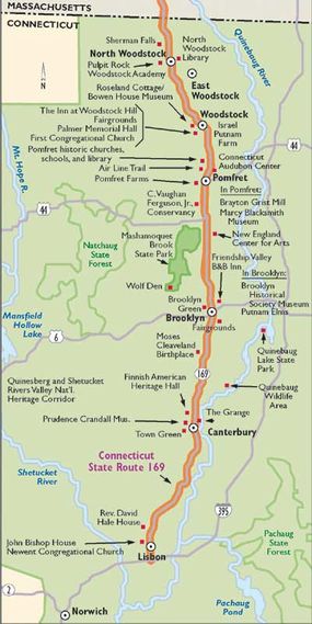
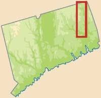
Consider everything you know about New England -- spectacular autumn color, historic buildings, charming cities -- and you will have an idea of what you will find on Connecticut State Route 169. Much has changed over the years on this byway, but the history and traditions of the area are still very much a part of the lives of the people who belong to the communities.
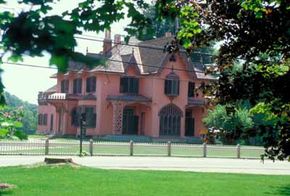
Take the opportunity to experience some of the sights along this historical stretch of road. Visit the beautiful churches in Pomfret that date back to the 1800s. Or find out what life was like for a prosperous family in the mid-19th century at the Roseland Cottage/Bowen House Museum in Woodstock. Or simply explore some of the towns at your leisure, admiring the distinctive architecture and well-kept parks.
Advertisement
As you travel the byway, you will visit many wonderful communities. The route crosses through Lisbon, where the feeling of an early American community is still evident. Explore Canterbury, where Connecticut's interpretation of Georgian architecture is prominent. Then you will find yourself in Pomfret, once known as "the other Newport" for its strong influx of wealthy summer vacationers. Finally, you will pass through Woodstock, with its many architectural surprises clustered around a town common. Traveling this byway, you will sense an area that is moving ahead in the times while still maintaining a sense of pride in its history.
Cultural Qualities of Connecticut State Route 169
The historic and cultural significance of this area was recently spotlighted by its designation as a National Heritage Corridor. The Quinebaug and Shetucket Rivers Valley National Heritage Corridor (Q-S NHC) recognized the great potential for recreation and site interpretation due to the byway's abundance of outstanding 19th-century mills, mill villages, and beautiful landscapes. State Route 169 forms the western edge of the Q-S NHC and is considered an important element in the Heritage Corridor, especially as a means for linking its many diverse historic sites.
In addition to two National Historic Landmarks (Prudence Crandall Museum and Roseland Cottage), there are more than 175 historic sites and districts recognized by local and state surveys and/or the State or National Registers of Historic Places. The National Register of Historic Places lists two districts along State Route 169 (Bush Hill and Brooklyn Green, both in Brooklyn), as well as individual properties. The rich architectural heritage of villages, such as Brooklyn, Pomfret, and Woodstock, is representative of the hill town communities that settled this part of Connecticut and are still very much intact.
Qualities of Connecticut State Route 169
The history of this ancient road is inextricably tied to the history of the hill towns of northeastern Connecticut. Since prehistoric times, the route has wound its way along, up, and down the spines of age-old hills in a north-south direction. Windham County historian Ellen Larned tells us that a Nipmuck Trail ran from Wabbaquasset (i.e. the Woodstock area) to the seashore. If some parts of that trail and today's State Route 169 are not the same, there were undoubtedly footpaths of American Indian origin that took much the same course. On the northern end, it seems certain that John Eliot and Daniel Gookin crossed portions of this route in 1674 as they made their way to what is now Woodstock. During the decade that followed other people made forays into Wabbaquasset territory, burning cornfields and American Indian forts. It is only logical to assume that they used American Indian trails and perhaps some part of what is now State Route 169.
The first improvements by Europeans most likely occurred after the settling of Norwich in 1659; Lisbon was then a part of Norwich. However, the course of the lower portion of the highway was changed sometime after 1854, detaching the most ancient part of the road in that region. At present, there is no documentation for the road at the southern end.
At the northern end, the Proprietor's Records of Woodstock record the laying of a road from North Running Brook, north of the village of Woodstock, to Sawmill Brook, in South Woodstock, by the first "Goers" during the summer of 1686. The public right-of-way was eight rods wide in some parts, and six rods wide in others (the rod used was probably 11 feet). This was quite a large width considering it was used primarily for foot traffic, occasional teams of oxen, and riding horses. This width allowed for common lands on either side of an improved, traveled way.

The Woodstock portion of the Norwich and Woodstock Turnpike was made free in 1836, while the rest of the road remained a toll road for another ten years. In 1846, the corporation persuaded the Connecticut assembly to relieve it of its obligations on the grounds that the cost of the road had been more than 14,000 dollars and that no considerable profit had ever been realized. Since the operation of the Norwich and Worcester Railroad, the income had not been sufficient to provide for the necessary repairs and no dividends had been paid for six years. Consequently, the railroad was blamed for the demise of the 19th-century turnpike era.
Railroads also had other effects on the hill towns. To Pomfret, where the railroad passed over the highway, it brought summer tourists and a grand way of life; to other towns bypassed in favor of the thriving mill towns along the Quinebaug, it brought a long, slow decline. The period of dormancy is in large part the reason why so much of the path of this historic highway has remained unchanged throughout the years. As for the Norwich and Woodstock Turnpike, it undoubtedly remained much the same until the advent of the automobile and the development of the state highway system in the 20th century, when it was first given the number 93, which was later changed to 169.
Early photographs are plentiful, showing portions of the road as a narrow, graded, and crowned dirt road. It has grown somewhat wider through the years, has been blacktopped along its entire length, and in recent years has been very well maintained. Even with all these improvements, one can still feel the bumps and turns of the ancient road, see the horizon ahead disappear and reappear, and feel a continuity through time with all who have traveled this beautiful road.
Qualities of Connecticut State Route 169
The spectacular views that travelers witness from State Route 169 are owned by the thousands of individual property owners that live along the corridor. The attractive pattern of land use that has evolved over many centuries is the result of the individual actions of the residents of the five towns that the corridor traverses. State Route 169 traverses the physiographic region of Connecticut known as the Eastern Uplands. Within the eastern uplands there are three distinct landscape types: Glacial Till Uplands -- the ridge tops and side hills, Drumloidal Glacial Till Uplands -- the more rounded and oval shaped uplands, and Glacial Outwash Plains -- the bottomlands.
These three landscape types form a subtle impression upon the visitor to northeastern Connecticut, and a visit along State Route 169 traverses all three. Starting from the south, the route parallels the Quinebaug River bottomlands, barely skirting the side hills until just north of Canterbury. Here the road intersects a drumlinelike formation, and then it descends back down into the bottomlands associated with Blackwell Brook. Just north of Brooklyn, the road starts to climb again across glacial till uplands, and then it reaches what is sometimes referred to as the Woodstock Drumlin Field.
The most visible landscape type comes from the view of the immediate roadway environment. This includes the close landscape of the villages, woodlands, and farmsteads adjacent to the road. This intimate setting, often framed by stone walls and mature lines of trees, is the most memorable experience along State Route 169, and this is one of the few areas where this type of southern New England landscape remains intact. The stone walls found along this route are the result of hundreds of years of agricultural development, and in that sense, the walls are irreplaceable.
The network of streams and wetlands found throughout the corridor also add to the beautiful scenery and natural qualities of the byway. Waterways such as the English Neighborhood Brook play throughout the long-distance vistas and the mature tree canopies on the route. Many of the lands and waters that compose this system of wetlands and waterways are already protected by existing floodplain and wetland ordinances, creating a backbone of greenways and open spaces that help to embrace and separate different uses of land.
Within the scenic views along State Route 169 are extensive areas of woodland. Many of these areas have avoided agricultural use to become mature woodland as the agricultural economy has been transformed from farming to manufacturing to a service-sector orientation. These woodlands continue to play an important role in the way both visitors and residents alike perceive the character of the corridor. The highly visible wooded hillsides that provide a particularly attractive setting for the towns and villages along State Route 169 are a main characteristic of the drive. When combined with the attraction of fall color, these wooded hillsides are even more enticing.
Find more useful information related to Connecticut State Route 169:
- Connecticut Scenic Drives: Connecticut State Route 169 is just one of the scenic byways in Connecticut. Check out the others.
- How to Drive Economically: Fuel economy is a major concern when you're on a driving trip. Learn how to get better gas mileage.
Advertisement

